Geospatial Breakthroughs Reshaping Telecom Networks
How location intelligence is redefining planning, optimization, and customer experience
6 Minute Read

Geospatial data has moved from a back-office mapping function to a planning, assurance, and customer-experience layer that touches every NA Tier 1 operator's RAN, transport, and OSS roadmap. As C-band densification continues, fiber-to-the-tower programs scale, and LEO and FWA reshape the access mix, the question for operators is no longer whether geospatial intelligence matters - it is which decisions are gated by it, and what the data, tooling, and integration costs look like.
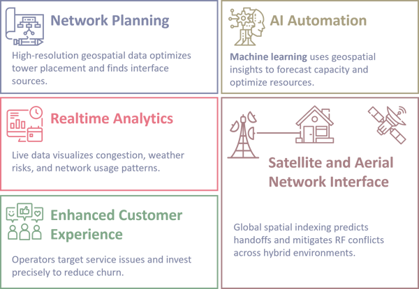
Network planning has shifted from coarse coverage maps to high-resolution 3D models that capture terrain, building heights and materials, vegetation, street canyons, and RF obstruction zones. This level of fidelity matters most for mid-band (C-band, 3.5 GHz) and mmWave (24+ GHz) deployments, where propagation is highly sensitive to clutter. The operational payoff is sharper gNB and small-cell siting, less overprovisioning, and the ability to identify structure-level coverage gaps - for example, the low-floor blockage in a high-rise that a planimetric coverage map will not show. (Some vendors and operators cite up to a 50x resolution improvement over legacy datasets; that figure depends on which baseline and which dataset, and is worth verifying against the specific GIS provider.)
Static maps cannot keep up with the dynamic behavior of mobile networks. Spatiotemporal analytics that fuse PM counters, crowdsourced and CDR-derived measurements, IoT telemetry, and weather feeds let operators see congestion hotspots, outage clusters, and traffic surges as they form. The practical use cases are predictive maintenance, SLA assurance, and capacity steering - including the classic suburban case where an evening traffic surge at a single sector is invisible to quarterly planning cycles but obvious in spatiotemporal views. The trade-off worth naming: real-time spatial fusion is a data-engineering problem (ingestion and schema unification across OSS, BSS, and probe sources) before it is an analytics problem.
AI and ML for network operations depend heavily on the quality and granularity of geospatial inputs. In-database ML platforms (Oracle Spatial, PostGIS with extensions, BigQuery GIS, Snowflake with H3 / S2 indexes) now run capacity forecasting, anomaly detection, and automated siting against trillion-row corpora without exporting to a separate ML environment. Done well, this surfaces traffic anomalies at the block, device-type, or floor level before customer-perceived degradation. The long-term arc is closer to TM Forum AN L3-L4 (closed-loop, cross-domain) operations, in which resources shift on geospatial demand signals - but most NA operators today sit at AN L1-L2, and the gap is rarely the model.
Fiber rollouts remain capital-heavy, and GIS-driven automation is reshaping the workflow. By integrating right-of-way records, underground-utility data (e.g., 811 / one-call datasets), environmental risk layers, and cost-optimized routing, GIS tools shorten planning cycles. Vendor and operator reports commonly cite 30-50% rollout-time reductions; that range depends on the baseline (manual vs. semi-automated), market, and program type, and is worth confirming against a specific deployment case. As fiber underpins 5G xHaul, FWA, and enterprise connectivity, GIS-based planning has moved from optional to mandatory in modern transport engineering. Operators are building 3D digital twins of cities, campuses, and network footprints. These twins simulate RF propagation, traffic load, infrastructure aging, weather impact, and interference, letting RF and transport teams test changes before they touch production. The benefits are real (lower change-risk, faster what-if analysis), but the trade-off is non-trivial: twins are only as accurate as their underlying clutter, propagation, and telemetry feeds, and ongoing curation cost is a line item operators tend to under-budget. As 6G research progresses (ITU-R IMT-2030 framework, 3GPP Release 19+ study items), digital twins are expected to evolve into AI-driven orchestration engines supporting zero-touch operations.
Geospatial analytics is sharpening customer-experience programs by exposing service quality at the neighborhood, household, and even foot-traffic level. The operational use cases - churn prediction, hyperlocal promotions, precision upsell, community connectivity offers - let carriers shift from market-level to block-level service models. The practical example: pinpointing a handful of homes at the edge of a coverage zone whose experience is dragging an NPS cohort, and targeting that fix rather than upgrading an entire sector. This is as much a BSS / CX problem (data unification across CRM, billing, and trouble-ticketing) as a network problem. Telecom networks remain critical to public safety and national security, and geospatial precision is central to that role. Operators support law enforcement, emergency response (E911 with vertical accuracy under FCC Z-axis rules), drone operations, and defense communications. Floor-level location using barometric pressure and elevation metadata is a documented capability in modern UEs; coverage and accuracy vary by handset, building, and reference data, and program teams should validate carrier and PSAP performance against the FCC Z-axis benchmark rather than vendor marketing. Long-horizon spatial pattern recognition also helps detect slow-moving DDoS reconnaissance and persistent network probes.
LEO satellites, HAPS, and drone-based connectivity are adding new layers of RF interference complexity. Global spatial indexing - combining elevation, airspace, and environmental factors with systems like H3 or S2 - helps operators model satellite handoffs and mitigate terrestrial-aerial conflicts. Operators do not control satellite constellations (Starlink, Kuiper, AST SpaceMobile), but customers expect a seamless experience, so handoff-zone modeling is becoming a planning requirement rather than a curiosity. Direct-to-cell partnerships (e.g., T-Mobile / Starlink, AT&T / AST SpaceMobile) make this concrete; specific service scopes and dates should be verified against current carrier filings.
As networks become more distributed, software-defined, and dependent on third-party assets (towercos, fiber wholesalers, hyperscaler edge, satellite partners), geospatial intelligence is becoming a foundational capability rather than a planning tool. Operators that can unify and act on geospatial data across RAN, transport, core, OSS, and BSS will compete on speed of decision and capital efficiency. The recommendation for program leaders is concrete: identify the two or three decisions in your current planning, assurance, and CX workflows that are gated by geospatial data quality, instrument them, and sequence the data-integration work before the analytics or AI investment. Skipping to the AI layer is the most common failure mode.